


Solar Eclipse of March 17 1904 from Paramaribo, Suriname
Computing...
The visibility of a Solar Eclipse depends on the specific observing location. To find out precise visibility information about the March 17 1904 Eclipse for any other location, use the following location search tool, the interactive map below, or browse the eclipse visibility by city in Suriname or by country .
Interactive Map of March 17 1904 Eclipse for Paramaribo, Suriname
Use the following interactive map to determine the precise eclipse visibility conditions for any location. By clicking on any point of the map, the eclipse circumstances will be automatically computed for that location.
Timezone: Loading...
Eclipse Appearance
The following diagram shows what the Annular Solar Eclipse of March 17 1904 was looking like at the instant of maximum eclipse as observed from Loading... (Loading...). Move the blue pin on the eclipse map to change the location and view the updated diagram.


Eclipse Local Circumstances
Start of Partial Eclipse
Start of Annular Eclipse
End of Annular Eclipse
End of Partial Eclipse
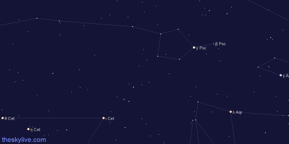
Star Map of Annular Solar Eclipse of March 17 1904
A fascinating aspect of a total solar eclipse is that, during the totality phase, the sky becomes dark and it is possible to see the brightest stars and planets. Since the totality phase is brief, it's helpful to know which celestial objects to look for.
This star map shows the location in the sky of the Moon, the Sun and the planets at the time of maximum eclipse as observed from Paramaribo, Suriname. The portion of the sky represented in this sky chart is 50°x25°. Our Online Planetarium offers a more complete and interactive tool to explore the stars, contellations and planets that what were visible during the totality phase across the full sky.
Visibility of March 17 1904 Eclipse from the Major Cities of Suriname
Through the links below you can access detailed information about how the Annular Solar Eclipse was visible from the major cities of Suriname:
Browse Visibility of March 17 1904 Eclipse by Country
- Afghanistan
- Albania
- Algeria
- Andorra
- Angola
- Antigua and Barbuda
- Argentina
- Armenia
- Australia
- Austria
- Azerbaijan
- Bahamas
- Bahrain
- Bangladesh
- Barbados
- Belarus
- Belgium
- Belize
- Benin
- Bhutan
- Bolivia
- Bosnia and Herzegovina
- Botswana
- Brazil
- Brunei
- Bulgaria
- Burkina Faso
- Burundi
- Cambodia
- Cameroon
- Canada
- Cape Verde
- Central African Republic
- Chad
- Chile
- China
- Colombia
- Comoros
- Congo (Kinshasa)
- Congo (Brazzaville)
- Costa Rica
- Cote d'Ivoire (Ivory Coast)
- Croatia
- Cuba
- Cyprus
- Czech Republic
- Denmark
- Djibouti
- Dominica
- Dominican Republic
- Ecuador
- Egypt
- El Salvador
- Equatorial Guinea
- Eritrea
- Estonia
- Ethiopia
- Fiji
- Finland
- France
- Gabon
- Gambia
- Georgia
- Germany
- Ghana
- Greece
- Grenada
- Guatemala
- Guinea
- Guinea-Bissau
- Guyana
- Haiti
- Honduras
- Hungary
- Iceland
- India
- Indonesia
- Iran
- Iraq
- Ireland
- Israel
- Italy
- Jamaica
- Japan
- Jordan
- Kazakhstan
- Kenya
- Kiribati
- North Korea
- South Korea
- Kuwait
- Kyrgyzstan
- Laos
- Latvia
- Lebanon
- Lesotho
- Liberia
- Libya
- Liechtenstein
- Lithuania
- Luxembourg
- Macedonia
- Madagascar
- Malawi
- Malaysia
- Maldives
- Mali
- Malta
- Marshall Islands
- Mauritania
- Mauritius
- Mexico
- Micronesia
- Moldova
- Monaco
- Mongolia
- Montenegro
- Morocco
- Mozambique
- Myanmar (Burma)
- Namibia
- Nauru
- Nepal
- Netherlands
- New Zealand
- Nicaragua
- Niger
- Nigeria
- Norway
- Oman
- Pakistan
- Palau
- Panama
- Papua New Guinea
- Paraguay
- Peru
- Philippines
- Poland
- Portugal
- Qatar
- Romania
- Russia
- Rwanda
- Saint Kitts and Nevis
- Saint Lucia
- Saint Vincent and the Grenadines
- Samoa
- San Marino
- Sao Tome and Principe
- Saudi Arabia
- Senegal
- Serbia
- Seychelles
- Sierra Leone
- Singapore
- Slovakia
- Slovenia
- Solomon Islands
- Somalia
- South Africa
- Spain
- Sri Lanka
- Sudan
- Suriname
- Swaziland
- Sweden
- Switzerland
- Syria
- Tajikistan
- Tanzania
- Thailand
- Timor-Leste (East Timor)
- Togo
- Tonga
- Trinidad and Tobago
- Tunisia
- Turkey
- Turkmenistan
- Tuvalu
- Uganda
- Ukraine
- United Arab Emirates
- United Kingdom
- United States
- Uruguay
- Uzbekistan
- Vanuatu
- Vatican City
- Venezuela
- Vietnam
- Yemen
- Zambia
- Zimbabwe
- Taiwan
- Christmas Island
- Cocos (Keeling) Islands
Eclipse Terminology
- Magnitude. The Magnitude of a Solar Eclipse is defined as the fraction of the diameter of the sun that is covered by the disc of the Moon at the time of maximum eclipse.
- Greatest Eclipse Point. In simple terms, this can be thought of the point on Earth having the best visibility conditions in terms of coverage of the disk of the Sun (i.e. magnitude) and duration. This definition is not 100% precise, a more formal and precise definition can be found on Fred Espenak's eclipse website.
- Local Cistumstances. The Local Circumstances of a Solar Eclipse are the computed local times at which the eclipse key events, such as first contact, start of total eclipse etc., occur.
Browse Other Solar Eclipses
Select a decade to visualize all the solar eclipses happeing in the selected time interval:
- Upcoming
- 1900-1909
- 1910-1919
- 1920-1929
- 1930-1939
- 1940-1949
- 1950-1959
- 1960-1969
- 1970-1979
- 1980-1989
- 1990-1999
- 2000-2009
- 2010-2019
- 2020-2029
- 2030-2039
- 2040-2049
- 2050-2059
- 2060-2069
- 2070-2079
- 2080-2089
- 2090-2099
Credits
Thee eclipse KML paths used for the maps visualization on this site are provided by Xavier M. Jubier (http://xjubier.free.fr/)